Wildfire Preparedness: What Nebraska's Record Fire Means for Your Evacuation Plan
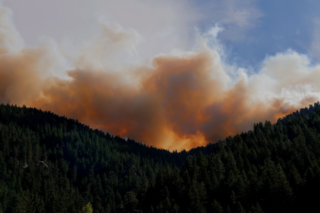
On March 12, 2026, the Morrill Fire ignited in western Nebraska and traveled roughly 70 miles in under 12 hours. By the time containment reached 98% on March 20, it had consumed 643,074 acres — the largest wildfire in Nebraska state history. An 86-year-old woman died trying to evacuate. The fire moved faster than many residents expected, faster than some could drive.
Nebraska is not a state most people associate with catastrophic wildfire. That disconnect is the problem. As of mid-March 2026, the U.S. has already burned over 522,000 acres nationwide — 422% of the 10-year average for this point in the year, according to the National Interagency Fire Center. The U.S. Drought Monitor reported in January 2026 that 69% of the country was under drought conditions. Fire season has not started in the West yet.
This is not a California problem. This is a dry-fuel-and-wind problem, and it can happen anywhere there is grass, brush, or timber.
Why Wildfires Kill People Who Think They Have Time
The leading cause of wildfire fatalities is late evacuation. People wait for official orders instead of acting on conditions. They underestimate fire speed. They go back for belongings.
A wind-driven grass fire like the Morrill Fire can move at 15-20 mph across open terrain. That is faster than a person can run and, on congested rural roads, sometimes faster than traffic. The fire reached communities with minimal warning because it ignited late in the afternoon and ran through the night.
FEMA's standing guidance is to leave when you feel unsafe, not when you are ordered to. Evacuation orders often come after conditions are already dangerous for departure. The window between "this might be fine" and "we cannot leave safely" can close in under 30 minutes in a fast-moving fire.
Your evacuation plan needs to account for the speed of fire, not the speed of bureaucracy.
The Three Zones of Defensible Space
If you live in or near any wildland-urban interface — and millions of Americans do without realizing it — your property's survival depends on what happens in the 100 feet surrounding your home.
A UC Berkeley study found that home hardening combined with clearing defensible space within 5 feet of the structure raised home survival rates to 40%, compared to roughly 12% for untreated homes. Ninety percent of homes destroyed by wildfire are ignited not by the fire front itself but by wind-borne embers that land on or near the structure.
The defensible space model, standardized by CAL FIRE and adopted by most western fire agencies, breaks down into three zones.
Zone 0: 0-5 Feet From the Structure
This is the ignition zone. Embers land here and find fuel — or they don't.
- Remove all combustible materials: mulch, dead leaves, woodpiles, propane tanks
- Replace organic ground cover with gravel, pavers, or concrete
- Clear gutters of all debris (leaf-filled gutters are one of the most common ignition points)
- Move patio furniture, door mats, and trash bins away from exterior walls
- Screen all vents and eaves with 1/8-inch non-combustible metal mesh to block ember entry
Zone 1: 5-30 Feet
This is your fuel-reduction zone. The goal is to break fire continuity so flames cannot carry directly to the structure.
- Trim tree branches to at least 10 feet from the roofline and chimney
- Remove dead branches, leaves, and pine needles from the ground
- Space trees so their canopies are at least 10 feet apart
- Trim tree limbs up to 6 feet from the ground to prevent surface fire from climbing into the canopy
- Keep grass mowed to a maximum height of 4 inches
Zone 2: 30-100 Feet
This is the buffer zone. You are not trying to eliminate vegetation — you are trying to slow and reduce fire intensity.
- Create horizontal spacing between trees and shrubs (minimum 10 feet between tree canopies)
- Remove dead trees and heavy brush accumulations
- Stack firewood at the far end of this zone, uphill from the structure if possible
A weekend of focused clearing in Zones 0 and 1 costs nothing but labor and more than doubles your home's odds.
Home Hardening: The Structural Side
Defensible space handles the fuel around the home. Hardening handles the home itself. Both matter. Neither alone is sufficient.
The most common entry points for embers are vents, gutters, gaps under roof tiles, and single-pane windows.
Priority upgrades, ranked by impact per dollar:
- Roof: Replace wood shake or shingle with Class A fire-rated material (metal, tile, or asphalt composition). The roof is the largest surface area exposed to ember rain.
- Vents: Install 1/8-inch metal mesh ember guards on all soffit, ridge, gable, and foundation vents. This is a sub-$100 fix that eliminates one of the most common ignition pathways.
- Windows: Upgrade to dual-pane tempered glass. Single-pane windows can crack and shatter from radiant heat at distances as close as 30 feet from the fire front, giving embers a direct path inside.
- Siding: Fiber cement, stucco, or masonry siding outperforms vinyl or wood in wildfire conditions. Vinyl melts and exposes the underlying structure.
- Decks and fencing: Wood decks attached to the home are direct fuel bridges. If replacement is not feasible, maintain the area under the deck clear of all debris and vegetation.
Building a Wildfire Evacuation Kit
A wildfire go-bag is not identical to a general bug-out bag. It has a different priority stack because wildfire evacuations have specific characteristics: they are fast, they involve driving through smoke and heat, and they often last 2-7 days.
Tier 1: Grab in Under 2 Minutes
These items stay in a single bag by the front door at all times during fire season.
- Prescriptions and medical devices (30-day supply minimum)
- Government-issued IDs, insurance documents, and property deeds (photocopies; originals in a fireproof safe or off-site)
- Phone charger and external battery pack
- N95 masks (minimum 2 per person — wildfire smoke particulate matter below PM2.5 penetrates standard cloth masks)
- Cash: $200 minimum in small bills (ATMs and card readers fail during power outages)
- One change of clothes per person in natural fiber (cotton or wool — synthetics melt)
- Contact list printed on paper with phone numbers for family, insurance agent, and veterinarian
Tier 2: Grab in Under 10 Minutes
- Laptop and backup hard drive
- Family photos and irreplaceable documents
- Pet carriers, leashes, pet food, and veterinary records
- 1 gallon of water per person per day for 3 days (FEMA standard)
- Non-perishable food for 3 days
- AM/FM battery-powered or hand-crank radio
- First aid kit
- Flashlight with extra batteries
Tier 3: Vehicle Prep
- Full tank of gas (do not wait for an evacuation order to fuel up — stations will be overwhelmed or closed)
- Wool blankets in the trunk (protection against radiant heat if caught in smoke)
- A paper map of your county with at least two evacuation routes marked — GPS and cell data may not function in fire zones, and digital maps require connectivity your phone may not have. If you carry the Deadnet USB, its offline maps and route-planning AI work without any signal.
- Dashcam or phone mount for documenting property condition (useful for insurance claims)
Keep one go-bag in your home and a duplicate set of Tier 1 items in your vehicle. If evacuation orders hit while you are at work, you should not need to drive home first.
Planning Your Evacuation Routes
One route is not a plan. It is a hope. You need at minimum two routes out of your area, ideally in different directions, because fire behavior is driven by wind and terrain — and both change.
Study your local road network before fire season. Identify:
- At least two roads leading away from the wildland-urban interface
- The location of emergency shelters (contact your county emergency management office or check the Red Cross shelter map)
- Choke points: single-lane roads, bridges, railroad crossings, and intersections that will bottleneck during mass evacuation
- The direction of prevailing winds during fire season in your area
Drive both routes during non-emergency conditions so you know travel times, road widths, and potential obstacles.
Establish a family communication plan before fire season starts. Cell towers are often the first infrastructure to fail in a wildfire zone — they burn, they lose power, or they overload from call volume. Agree on a meeting point outside the evacuation zone and an out-of-state contact who can relay messages between family members.
When You Cannot Evacuate
Sometimes the window closes. If fire overtakes your route and evacuation is no longer safe:
- Stay inside a hard structure. A house, even a non-hardened one, provides more protection than an open vehicle.
- Close all windows and doors. Shut off HVAC systems to prevent smoke intake.
- Move to the room farthest from the approaching fire, on the side of the house opposite the flames.
- Fill bathtubs and sinks with water. Place wet towels at the base of exterior doors.
- If trapped in a vehicle, park in a cleared area away from vegetation. Close all windows and vents. Lie below the window line. The vehicle's metal body provides temporary shielding from radiant heat.
This is a last resort. It is survivable in many cases, but it should never be your plan.
The Insurance Problem No One Talks About
As of 2025, the Insurance Information Institute reported that major U.S. insurers pulled out of high-fire-risk markets in California, Colorado, and Oregon, leaving hundreds of thousands of homeowners without coverage or forcing them into state-run plans of last resort with higher premiums and lower limits.
Before fire season:
- Verify your homeowner's policy is active and covers wildfire specifically
- Document your property: walk through every room with a video camera, narrating contents and serial numbers, and store that video in two locations (cloud and a physical drive off-site)
- Confirm your policy's replacement cost versus actual cash value — the difference can be six figures on a total loss
- Keep receipts for home hardening and defensible space work; some insurers offer premium discounts for documented mitigation
If your carrier has dropped your coverage or you're in a FAIR plan, start shopping before fire season begins. Trying to find coverage after a fire watch is issued is like buying flood insurance during a hurricane.
Your Next Step
Pick one of the three defensible space zones and clear it this weekend. Zone 0 — the 5 feet immediately surrounding your home — takes most people 2-4 hours and costs nothing. Remove the dead leaves from your gutters, pull combustible materials away from your walls, and screen your vents. That single action, according to the UC Berkeley research, meaningfully increases your home's survival odds.
If you want the full technical reference — including the FM 21-76 survival manual's guidance on fire behavior, improvised shelter, and smoke navigation — the Deadnet USB carries military and government survival sources offline with an AI assistant that can walk you through scenario-specific plans, no internet required.
The Morrill Fire covered 70 miles in half a day. Your preparation window is right now.
Get offline access to expert survival knowledge
Military and government survival sources. Local AI. No internet required.